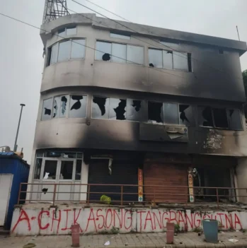
The strategically significant Doklam Plateau and Cho La have opened for domestic tourists under “Battlefield Tourism,” marking an end to an eight-year closure that followed the 2017 Doklam standoff. This new “Bharat Rannbhoomi Darshan” initiative includes three main sites in Sikkim, also designated as “destinations of valour.” This “battlefield tourism” aims to promote both the economy and national pride. However, former Army Commander Lt Gen R P Kalita said, “Since 2017, there has been no further Chinese construction observed, but the Line of Actual Control in the northeast remains the biggest challenge for the defence forces.”
The Siliguri Corridor, often termed the “Chicken’s Neck,” represents a cardinal geopolitical asset for India, embodying both exposure and strategic depth in the nation’s security position. This narrow strip, measuring 20–22 kilometers in width and extending up to 60 kilometers in northern West Bengal, serves as the sole terrestrial connection between mainland India and its eight northeastern states (Arunachal Pradesh, Assam, Manipur, Meghalaya, Mizoram, Nagaland, Sikkim, and Tripura). As NDTV reported (2005), serving a population of nearly 45 million, the corridor facilitates indispensable logistics, handling more than 95 percent of traffic (a daily transit of over one million vehicles and 2,400 metric tonnes of goods)—the “lifeline of the Northeast.”
Any disruption by conflict, natural disaster, or blockade would isolate nearly 45 million people from essential supplies of food, fuel, and military resources, resulting in substantial economic losses. Its centrality is underscored by connectivity hubs like roads, railways, and airports, with Siliguri city acting as a nexus linking Bhutan, Nepal, Bangladesh, Sikkim, Darjeeling, Northeast India, and the mainland.
(Image source : The Borderlens)
The corridor’s strategic gravity is underscored by its proximity to four sovereign states (Nepal, Bhutan, Bangladesh, and China), creating a kinetic bottleneck in any regional conflict. This positioning renders it susceptible to encirclement and isolation, amplifying its role in Sino-Indian rivalry. Strategic postulates such as a “Doklam-style” response to mitigate Beijing’s influence in Bangladesh’s Rangpur Division, and cautions against granting access liberties to Nepal due to its Sino-centric alignment, reflect ongoing strategic apprehensions.
Former Chief of the Army Staff General Manoj Pande (2025) has called for a “whole-of-nation approach” involving coordination between armed forces, central agencies, and state governments to secure the area. Former Eastern Command Chief Lt Gen Kalita described it as the “lifeline of the Northeast,” emphasizing uninterrupted connectivity. Former head of the Defence Intelligence Agency, Lt Gen. Kamal Davar (2025), warned that blockages from Nepal, Bangladesh, or China could sever India’s link to the Northeast. This convergence of views highlights the corridor’s inherent paradox as both a logistical artery and a strategic fragility.
Historically, the corridor’s fragility is fundamentally rooted in the 1947 Partition, where colonial demarcation decisions created this narrow geostrategic corridor. Geographic encumbrances, coupled with demographic saturation, flux within communities, and socio-political complexities, have compounded its vulnerability.
The 1962 Sino-Indian War unequivocally revealed these susceptibilities, as Chinese advances threatened to sever the Northeast, prompting a strategic force reconfiguration. The 1971 Indo-Pakistani War initially alleviated geopolitical peril by establishing Bangladesh and eliminating East Pakistan’s external strategic threat through India’s support for the Mukti Bahini (the Bengali freedom fighters) and a decisive eastern campaign.
However, the massive refugee ingress strained resources, exacerbating communal friction and insurgencies like the United Liberation Front of Assam (ULFA), fuelled by anti-immigration sentiments and claims of being threatened by Indian political control. The corridor’s vulnerability is intensified by ethnic insurgencies and separatist movements in Northeast India, which external actors like China could exploit through proxy support or regional instability.
The 2017 Doklam standoff, during which Indian forces blocked Chinese road construction toward the Jampheri Ridge, accentuated the corridor’s strategic exposure. Geospatial intelligence data (MAXAR-2023) reveal extensive Chinese infrastructural footprints, including roads, bunkers, and settlements designed to achieve irreversible territorial realities. In conjunction with initiatives including the Lalmonirhat airbase in Bangladesh, analysts view this as part of a comprehensive strategy of geopolitical encirclement around India’s northeast. China’s forward troop projection (a “salami-slicing” strategy) from the Chumbi Valley poses an unambiguous strategic challenge to the corridor by imperilling the isolation of India’s vital logistical channels to the Northeast.
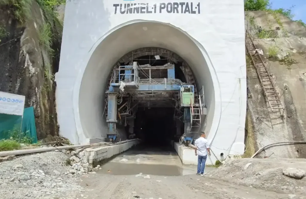
The Sivok-Rangpo rail project that will connect to Sikkim in progress . (Source : The Borderlens)
This has been described by British journalist Humphrey Hawksley in 2021 as a plausible “decapitation” strategy, noting that the corridor’s narrowness makes it India’s geopolitical “Achilles’ heel.” The salient and proximate adversarial pressure arises from China’s ambitious operational footprint in and around Bhutan. Citing the 1890 (Sikkim-Tibet Convention) Convention of Calcutta, Beijing claims the Doklam Plateau and has constructed over 22 villages and settlements (including the establishment of approximately 1,000 military structures with about 2,284 residential units) in disputed areas (appropriating approximately two percent of territory historically claimed by Bhutan) since 2020. This expansion has been interpreted as a “fait accompli” strategy to alter the ground realities in its favour.
However, former Director General, Defence Intelligence Agency, Lt Gen. Davar has also noted its susceptibility to blockages from China, Nepal, and Bangladesh, which could compromise connectivity to the Northeast, undermining economic and military stability. China’s investments in Bangladesh, Nepal, and Bhutan (e.g., the China-Myanmar Economic Corridor and Belt and Road Initiative) are geopolitical manoeuvres to encircle the corridor, creating debt-trap leverage that could pressure India’s regional hegemony. China’s BRI projects, such as the Lalmonirhat airbase 20–100 kilometers from the corridor, and increased Chinese nationals in Rangpur for infrastructure, elicit apprehensions of surveillance and systemic disruption.
Bangladesh’s shifting geopolitical orientation under Muhammad Yunus adds another layer. Positioning itself as the “guardian of the ocean” for India’s landlocked northeast, it leverages control over its maritime chokehold, with the corridor passing through its territory. This discourse obfuscates strategic calculus but indicates an inclination toward China and Pakistan, including requests for Lalmonirhat airbase upgrades into a multi-functional command and control centre for real-time monitoring near the corridor.
Such developments form a near-perfect encirclement of Siliguri, combined with the Chumbi Valley presence. Assam Chief Minister Himanta Biswa Sarma articulated acute apprehension regarding external entities attempting to influence residents of India’s Siliguri Corridor by invoking their historical affiliations to Bangladesh. Speaking in Dhubri (October 2025), he warned that “Bangladesh has two vulnerable chicken necks of its own, including a narrow stretch near Meghalaya connecting Chittagong port, which is even thinner than India’s Chicken’s Neck.” He emphasized that any threat to India’s corridor would prompt retaliation against both of Bangladesh’s strategic chokepoints.
India has fortified the Siliguri Corridor, transforming it into a formidable defensive area with approximately 100,000–150,000 personnel across the Army, paramilitary, and Air Force. Chief of the Army Staff, General Upendra Dwivedi (2025) called it India’s “strongest military region,” emphasizing rapid mobilisation from West Bengal, Sikkim, and the other northeast states. The Eastern Command’s Trishakti Corps (XXXIII Corps) at Sukna, with 45,000–60,000 troops including infantry, artillery, and T-90 tanks, was re-raised in 2011 for mountain warfare.
Exercises like Teesta Prahar and Trishakti Prahar (May 2025) simulate Chumbi Valley scenarios, with mountain strike units (10,000–15,000) preparing for potential “Siliguri Blackout” situations. Paramilitary forces (BSF, SSB, ITBP, and CRPF) ensure border security, conducting over 30 multi-agency drills in 2025 for hybrid warfare response capability.
As per Economic Times (2021) and India Today (2025), air defenses include a BrahMos regiment (300–500 personnel, 290–450 km missiles), 18 Rafale jets at Hasimara, an S-400 battery (deployed April 2025, 36 targets at 400 km), and Akash systems, while Bagdogra hosts MiG-29s and UAVs.
In tandem with military fortification, India is undertaking major infrastructure development to ensure assured supply-chain resilience. The Sevoke-Rangpo railway and Shillong-Silchar expressway improvements can enhance troop mobility and commercial flow optimisation. The envisioned Chicken’s Neck Tunnel Project (a partnership between the Northeast Frontier Railway and NHAI) includes a 22-km Dumdangi-Rangapani-Bagdogra tunnel designed for dual road-rail access, providing a direct connection to the Gorakhpur-Siliguri expressway.
Former Army Commander Lt Gen Kalita said, “There are 19 helipads, 126 roads, and eight tunnels under construction in the northeast. Through 2023, construction of 15 roads and the Nechiphu tunnel was completed, and the Trans-Arunachal Highway has already been sanctioned and will start soon. A total of 54 of the 662 border villages identified under the Vibrant Villages Programme under the Eastern Command have been identified for priority development.”
The India-Bhutan railway project holds profound geopolitical ramifications for India’s security, as Bhutan shares a border with the vulnerable corridor. Following up on progress, including a September 2025 agreement for two cross-border lines — Kokrajhar-Gelephu (69 km, ₹3,456 crore) and Banarhat-Samtse (20 km, ₹577 crore) — it aims to upgrade trade, tourism, and defense supply chains while mitigating Beijing’s geopolitical footprint.
The railway will increase accessibility by providing auxiliary transport channels for troops and equipment, alleviating pressure on the Siliguri Corridor and boosting reaction capability. It will facilitate superior surveillance along borders with Bhutan and China, counter Beijing’s expanding commercial footprint in the region, and promote stability through development and cooperation. The Sela Tunnel ensures all-weather access in Arunachal Pradesh, and the Chicken’s Neck Tunnel Project integrates rail-cum-road for critical transport access. Modernisation of the Siliguri locomotive shed and 9,000 kilometers of northeast roads, including 1,450 kilometers along borders, will facilitate rapid troop movement.
Given the corridor’s vulnerability, the central government has developed alternative access routes to the Northeast. The Kaladan Multimodal Transit Transport Project (KMTTP) interlaces Kolkata and Sittwe (operational), with completion targeted for 2027. The India-Myanmar-Thailand Trilateral Highway connects Moreh to Thailand, featuring outreach to Southeast Asian countries. Bangladesh corridors include the Akhaura-Agartala rail, Feni Bridge, and Chittagong/Mongla port access, cutting travel length by 1,000 km and significantly reducing transit mileage.
Despite impressive progress, multiple challenges persist, such as rugged geography, monsoon-driven landslides, and steep project outlays that delay infrastructure projects. Geopolitical frictions and sensitivities also hinder regional cooperation, as neighbouring states sometimes perceive India’s projects as defense-oriented expansion.
Furthermore, reliance on Bangladesh and Myanmar for transit makes these alternatives vulnerable to political instability in the northeastern borderlands. Conservationist and indigenous population concerns add another layer of political complexity, especially where infrastructure intersects with ecologically sensitive zones.
The Siliguri Corridor remains a vital but vulnerable chokepoint that embodies a national security challenge, balancing internal instability and external geopolitical strain. Once an area of exposure, it is now a fortified defense zone integrating military, infrastructure, and diplomatic efforts. Despite China’s aggressive posture, Dhaka’s fluctuating geopolitical orientation, and domestic separatist movements, India’s strategy focuses on strategic durability through enhanced connectivity and cutting-edge security systems.
Key actions include accelerating alternative access routes and modernising military installations. Short-term goals focus on completing connectivity projects, medium-term plans prioritise the IMT Highway, and long-term visions aim to transform the northeast region into a commercial hub and strategic nexus linking the Bay of Bengal to the Mekong, making the corridor a fortified gateway.