G7 and Quad will discuss the rising clout of China and its aggressive posture in the Indo-Pacific.
Chinese research and survey vessels have been active in the Indian Ocean, working on multiple objectives. One of these objectives was the recent release of Mandarin names for 19 sea-bed features. In addition, the vessels also map the ocean around the 90-degree ridge area. This mapping activity is aimed at facilitating future submarine forays into the Indo-Pacific. By conducting this research and mapping, China is positioning itself to better understand the Indian Ocean’s geography and potential submarine routes, which could have implications for regional security dynamics.
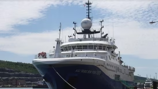
On April 13, the Chinese research/survey vessel Hai Yang Shi You 760 crossed the Malacca Straits after conducting ocean bed mapping in the Indian Ocean for nearly four months. The vessel, as per marine traffic website, is off the coast of Singapore and headed towards the Chinese port of Zhangjiang after restocking supplies at the Indonesian port of Balikpapan.
Over the past decade, the Chinese research vessels and strategic satellite tracking ships have been operating in the Indian Ocean region with a plan for creating an alternative sea route via Lombok, Ombai-Wetar straits of Indonesia to reach the eastern shores of Africa through the South Indian Ocean route. While submarines have to surface when they enter the Indian Ocean through Malacca and Sunda Straits due to depth issues, Chinese nuclear submarines can easily enter the Indian Ocean via the Lombok and Ombai-Wetar straits without giving up their position and proceed towards Africa or patrol the Indo-Pacific.
With the PLA Navy now the biggest naval force on the planet in size and numbers, China is expanding its global footprint through sea-power and there are concerns that Chinese carrier strike forces may start patrolling the Indo-Pacific by 2025 if not earlier. This is in sharp contrast to Beijing treating the South China Sea as its own backyard and trying to restrict global movement of ships by imposing identity restrictions and using overt force for access restriction and denial.
As a part of its expanding naval footprint, China is engaging island nations off the eastern coast of Africa by co opting them in Belt Road Initiative as well as overtly gifting off-shore patrol vessels in the name of maritime security. Given that nations on Africa’s eastern seaboard—from South Africa to Djibouti—are under Chinese debt, the maritime security of the Indo-Pacific looks grim as even big nations like Indonesia apart from nations like Sri Lanka, Pakistan, Myanmar, Cambodia, and Laos are under economic levers of Beijing. Add to this, the Chinese engagement of Shia-Sunni powers in the Middle-East and the maritime security scenario becomes bleak for democratic powers like India, Australia and Japan.
The rising clout of China and its aggressive posture in the Indo-Pacific will be a subject of discussion at the G-7 summit in Tokyo and the QUAD summit in Sydney next month. With President Xi Jinping the undisputed dictator of the Communist Party of China (CPC), the expansion of the authoritarian Middle-Kingdom can only be countered by faster decision making from the democratic powers. Or else the dice is loaded in favor of China.
Source: HindustanTimes