The National Remote Sensing Centre, one of ISRO’s prominent facilities, has captured satellite imagery depicting the dramatic transformation of the South Lhonak lake in Sikkim. These images vividly showcase the before-and-after scenes of the widespread devastation triggered in the region.
The acquisition of this crucial satellite data was initiated following reports of a flash flood at the Meilli CWC gauge site along the Teesta River, with preliminary suspicions pointing towards an outburst of the South Lhonak Lake as the possible cause.
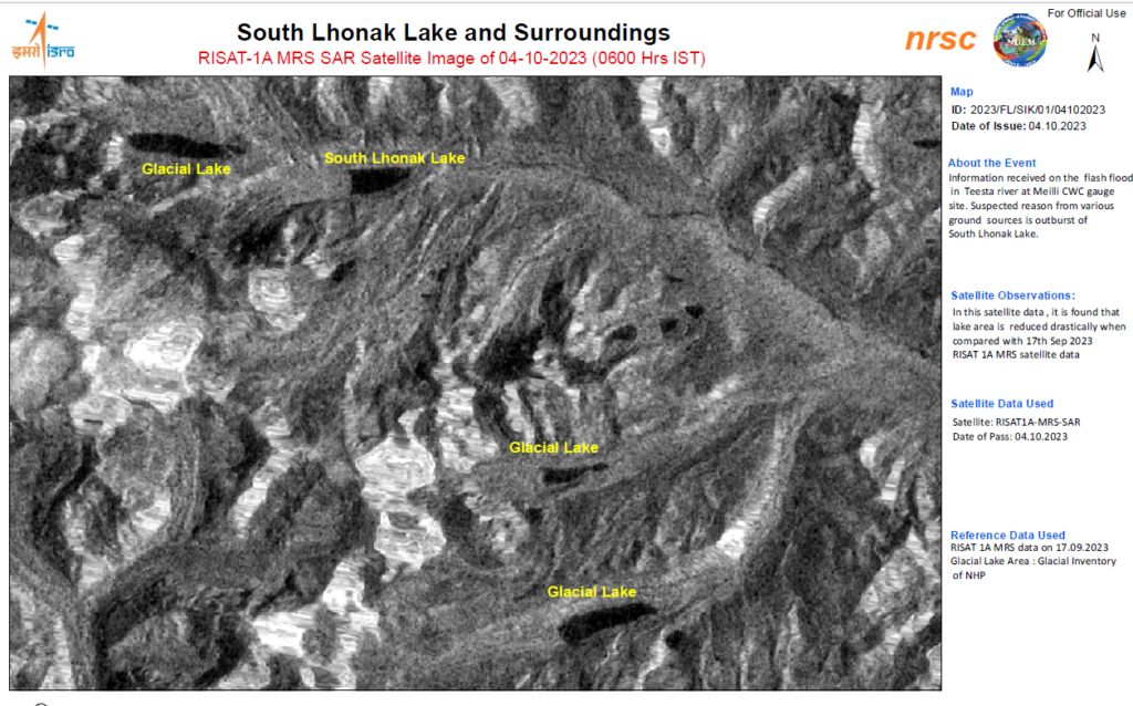
The satellite data analysis reveals a substantial reduction in the size of the lake when compared to its state on September 17, 2023. This reduction in the lake’s area is attributed to a Glacial Lake Outburst Flood (GLOF) originating from sections of the Lhonak Lake in Mangan District. This event, which occurred in the early hours of October 4, 2023, led to a rapid surge in water levels with extremely high velocities downstream, affecting the Teesta River Basin and causing severe damage to the districts of Mangan, Gangtok, Pakyong, and Namchi.
The outburst in sections of the Lhonak Lake in North Sikkim resulted in a significant increase in water levels, with velocities reaching nearly 15 meters per second. These surging waters crossed the CWC Melli site, measuring 227 meters, approximately 3 meters above the designated Danger Level, at 6:00 AM.
According to information from the Central Water Commission (CWC), the flood event transpired at midnight on October 3, 2023. Subsequent flood forecasts were made simultaneously for both India and Bangladesh at 6:00 AM and 2:00 PM. As of 6:00 AM, the Teesta River was flowing below the warning level at the CWC Domohani FF Station, with a water level of 84.83 meters, but it was anticipated to surpass its warning level within the next 6 hours.
ISRO has issued a statement highlighting that the observed bursting of the lake resulted in the drainage of approximately 105 hectares of land between September 28, 2023, and October 4, 2023, as evidenced by the satellite images. This drainage event is believed to have contributed significantly to the flash flood downstream. In response to these developments, ISRO has announced its commitment to maintaining ongoing surveillance of the South Lhonak Lake using satellite data, furthering its efforts to monitor and analyze the situation in the affected region.