A five-day drive in Arunachal’s border district teaches villagers, soldiers and officials what to do when a glacial lake gives way.
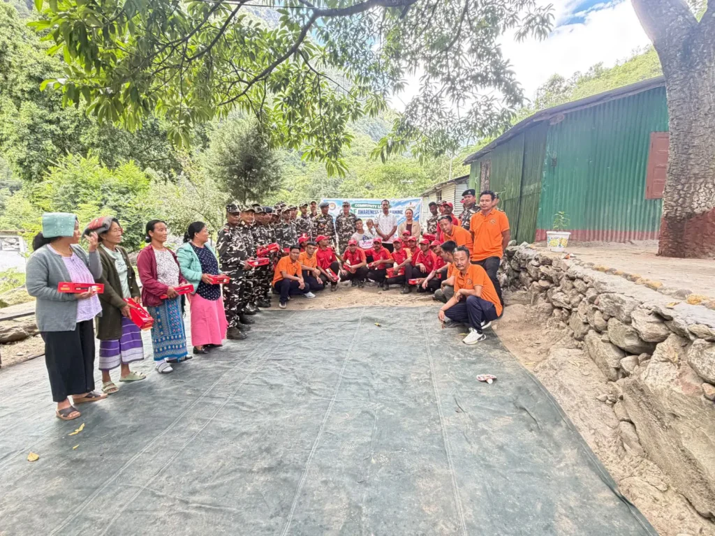
At the SSB Out Post at Donghseng Mang, Lungla, the last session of a five-day awareness programme ended last week. Sashastra Seema Bal personnel sat beside villagers, listening to the district’s disaster officers. The subject was the sudden release of water from a high-altitude lake, which the mountains have produced for millennia. What has changed is how often it happens, and how many people now live in its path.
Tawang has good reason to take that seriously. In the Mago area of the district, at least seven high-risk glacial lakes have been identified, and six of them drain into a common channel that passes through several villages, including Duri. Across Arunachal Pradesh, the National Disaster Management Authority has flagged 27 high-risk glacial lakes in five districts.
Learning the route before the water comes
The campaign, held in the vulnerable downstream stretches of the Mago and Sela regions, moved through Chaksam, Phongda, Grangkhar and Khet Bridge before ending at Lungla. Its message was simple. Know your warning, know your route, and do not wait.
District Disaster Management Officer Genden Tsomu told participants at Donghseng Mang that the SSB camp sits low in the valley and would be exposed early. She urged timely warnings, robust evacuation plans and locally workable alert systems. Anyone who spots a sign of a flash flood, she said, should immediately warn the neighbouring communities.
Senior Consultant Dr. Bhupen Mili explained what causes an outburst and what it can do. He also gave participants an estimate of how long floodwater might take to reach the camp. Time is the most important number in any GLOF plan, and it is short. He walked them through safe evacuation routes and identified safe locations. He stressed leaving early and acting as a coordinated community.
At Chaksam, ZPM Kyidphel Tenzin Monpa and Assistant Commissioner Sange Norbu joined the session and spoke with residents. At Grangkhar, officials identified the village as highly vulnerable. They advised residents to pick their own safe ground and evacuation routes now, before an emergency forces the choice.
Throughout, State Disaster Response Force personnel gave hands-on training in life-saving skills, search and rescue, and emergency response. The aim was to build capacity in the communities themselves, since outside help may take hours to reach a remote valley.
Why this matters: what Sikkim taught us
The stakes are clear from what happened in Sikkim. On the night of 3 October 2023, frozen moraine collapsed into South Lhonak Lake, sending an impact wave of around 20 metres through the lake and breaching its natural dam. The flood raced down the Teesta. It destroyed the 60-metre-high Teesta III dam at Chungthang and caused damage along 385 kilometres.
The disaster killed 55 people, and 74 were reported missing. Bridges, highways and hydropower installations were wrecked. The flood struck in the early hours, outside the monsoon, when few expected it.
A pattern across the Himalaya
Nepal has lived with this hazard for decades. The 1985 Dig Tsho outburst in the Khumbu destroyed a nearly finished hydropower project and swept away bridges and farmland. In 2016, a Tibetan lake burst down the Bhote Koshi corridor, wrecked stretches of the highway to China and badly damaged a power plant.
The recent events are more alarming. On 8 July 2025, a flood from a previously unnoticed lake on a Tibetan glacier hit Rasuwagadhi, killing at least nine people and leaving 19 missing. In August 2026, a far larger disaster struck the same corridor.
Early analysis pointed to a large section of glacier and rock breaking away and forming a debris flow. Chinese monitors recorded only six to seven minutes between the collapse and the surge reaching the border port at Gyirong.
Warning systems are thin. In Nepal, formal early-warning infrastructure covers only two lakes, Tsho Rolpa and Imja Tsho. Where the effort was made, it worked. In 2016, Nepal and UNDP lowered the water level in Imja Tsho and installed community-based early-warning and response systems. The trend is heading the wrong way, though. ICIMOD data shows the gap between major glacial hazard events in the Hindu Kush Himalaya shrinking from five to ten years to one or two.
The lesson for Tawang
These disasters share a common thread. Lakes and glaciers cannot be controlled everywhere, and the water arrives faster than a government can respond. What saves lives in those minutes is a warning that reaches every household and people who already know where to run.
That is what the Tawang programme tried to build. It covered locally available early-warning mechanisms, evacuation procedures, identified safe locations, and coordination between villagers, security forces and the district administration. Participants were asked to follow official advisories and to stay alert without panicking.
None of this can promise that a lake in Mago will never burst. It can ensure that if one does, the people of Duri, Grangkhar and Donghseng Mang know what to do. In the Himalaya today, that is the best protection available.